GPS Camera - GeoTag Map
Capture photos with precise location data and never lose a spot again. Perfect for fieldwork, research, travel, and documenting important locations with professional accuracy.
Why Professionals Choose GPS Camera
Find Any Location Again
Every photo captures exact GPS coordinates, altitude, and timestamp. Return to the exact spot weeks or months later – perfect for tracking field sites, documenting discoveries, or revisiting your favorite places with pinpoint accuracy.
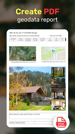
Professional Documentation Made Easy
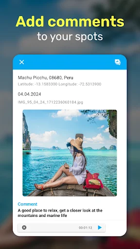
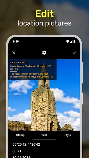
Add timestamps, location stamps, and voice or text notes to your photos. Export your geotagged images in KML, CSV, or XLS formats for reports, analysis, and sharing with your team or clients.
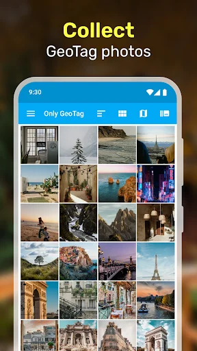
Visualize Your Photo Journey
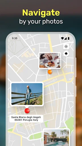
See all your geotagged photos displayed on interactive maps with satellite or standard views. Organize your images by location, time, or distance – making it simple to track patterns, plan routes, or tell visual stories.
Works for Any Field
Whether you're documenting crops, tracking wildlife, surveying real estate, or capturing memories, this app adapts to your needs. Add geotags to new photos or update existing images in your gallery with precise location data.
🗺️ GPS Camera App - GeoTag Map! 📍 📸
📸 Try a fantastic GPS Camera with Timestamp! 🌍
GeoTag: Improve Your Photography with the Ultimate GPS Camera App!
GPS camera app with GeoTag. GeoTag enhances every photo with precise GPS photo location data. GeoTag is your go-to solution for comprehensive geo tagging.
GPS Camera Technology: Our app uses cutting-edge GPS camera technology to embed accurate GPS photo location data directly into your images, ensuring every photo is enriched with precise location information.
GPS Camera Integration: With GeoTag, you can view your photos on a GPS Camera, providing a visual journey of your photographic trail. It is ideal for tracking your travels or documenting specific locations.
GPS Camera with Timestamp: Add detailed timestamps and location data to your photos with the GPS camera with time stamp feature. Customize your geostamps to add depth to every shot.
🧭 Find your GPS photo location! 📌
GeoTagging: Adding a geotag to your photos is simple with GeoTag. Our intuitive interface allows you to geotag photos as you capture them or add geotags to existing images in your gallery.
Map GPS Camera Visualization: The map GPS camera feature lets you see your geotagged photos on various map views.
Geo Map Camera Options: The geo map camera functionality allows you to view your photos on different map styles, including satellite and standard views, perfect for visualizing your photo locations in detail.
Geotag Photos for Every Scenario: Whether documenting site-specific data for work or capturing personal moments, our geotag photo app adapts to your needs.
- From real estate to agriculture: GeoTag is the ideal tool for any field requiring precise location data.
- Map Photo Location Accessibility: Easily access and display the map photo location of your images.
- Share and Export: Use GeoTag to share your geotagged photos with friends, family, or colleagues.
- Export your images with geostamps in various formats, including KML, CSV, and XLS files.
🌎 Get a GPS Camera with Time Stamp - Try it! 🗺️
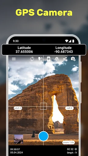
Camera Mode: Launch the app to enter Camera Mode, where you can capture photos with real-time GPS coordinates, altitude, and accuracy displayed on-screen. Every image taken is automatically geotagged, ensuring precise location data is embedded in the EXIF metadata.
Image Mode: View your geotagged photos, their coordinates, and their locations on a map. Add geostamps, edit geodata, and add text or voice notes for additional context.
Gallery Mode: Organize your images by name, creation time, or distance.
📸 Transform your mobile device into a powerful GPS camera with GeoTag! ✨
- Agriculture: Collect and analyze vital geodata for farming applications. Use the map gps camera to document field conditions, crop health, and more.
- Urban Planning and Reporting: Capture and geotag photos of urban issues like fallen trees or parking violations. Use the gps image camera to document and report hazards accurately. The Ultimate Free Geo Camera App.
🌟 Join the GeoTagging Revolution!
- GeoTag Photo App: Enhance every photo with detailed geotags, timestamps, and location data.
- Add Geotag Easily: Use our user-friendly tools to add effortlessly geotags to new or existing photos.
- GeoTag Map Camera: Navigate through your geo-tagged photo collections, discovering patterns and stories hidden in your travels.
- GeoTag Photos: Ensure every image tells a complete story with precise GPS data.
- Map Stamp Camera Features: Customize your geostamps to include dates, times, and specific locations.
- Geo Camera App Free: Start geotagging today at no cost, with robust features rivaling premium apps.
See GPS Camera in Action
Trusted by Researchers and Field Professionals
Wow... this is exactly what I was looking for... right after installing I love the details in the camera interface... uncluttered with real-time GPS coordinates. I study fungi in the forests and found an astonishing orange shelf fungus 3 weeks ago but Google photos could not display accurate coordinates when I returned to find the fungi. This app literally walked me back to the exact location and now I have better pictures and a spore sample. So far no ads and no problems. Excellent app!
We used this app in the field to do some vegetation species identification and geo-location in the middle of nowhere (the Kalahari) and it worked beautifully!
Thanks for developing this. It's easy to use and does a great job of adding EXIF Geo Tags quickly. Supper quick response to email query also. Good job!
Cool stuff! It gave the exact location from where I took a single picture.
Good camera for day n night, to take the cross off double tap the screen.
Good app to capture latitude and longitude of a picture taken